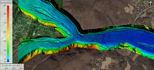
In the fall of 2024, the Interstate Commission on the Potomac River Basin (ICPRB) and its partners at the USGS Eastern Ecological Science Center in West Virginia and the USGS Earth Resources Observation and Science (EROS) Center in South Dakota completed Phase 3 of a LiDAR (Light Detection and Ranging) remote sensing project to map the bottom of the Potomac River.
LiDAR creates a highly detailed model of the river, which helps scientists better understand the depth, width, and flow of water through the channel.
During this recent phase of the project, the section of river between Cumberland and Jennings Randolph Reservoir was mapped using specialized equipment attached to an airplane.
Data from the maps allow construction of 2D and 3D computer models of the river. ICPRB uses mapping data to estimate the arrival time and peak concentrations of contaminant plumes to help protect drinking-water supplies for the Washington, D.C. metropolitan area.
Other organizations are using the data for engineering studies for bridges and roads, mapping aquatic habitats for biological assessments, flood mapping, and many other applications.
Previous Work
In October 2019, scientists from eight USGS Science Centers completed a multidisciplinary data collection effort using new technologies to map and validate bathymetry over a large stretch of the non-tidal Potomac River. ICPRB staff provided additional support.
The work was initiated as an effort to validate commercially acquired bathymetric light detection and ranging (lidar) data collected over two areas of interest and jointly funded through a partnership between the USGS and the Interstate Commission on the Potomac River Basin (ICPRB).
Work continued in 2020 to compare delivered airborne lidar data to bathymetric data collected in the field using more traditional means such as boat-based sonar and wading RTK-GPS surveys.
In addition to accurately measuring river bottom elevations with GPS and sonar, remote sensing imagery was collected in the field using unmanned aircraft systems (UAS) to test new technologies.
Phase 4
Phase 4 of the project is expected to be completed once funding is identified. When the project is completed, map data will be available for the entire reach of the Potomac River. The work is part of a national pilot project by USGS.
sources: Interstate Commission on the Potomac River Basin, USGS
Leave a Reply
You must be logged in to post a comment.